OpenZhenZhen AI 프롬프트 갤러리 · gpt-image-2.5 · image
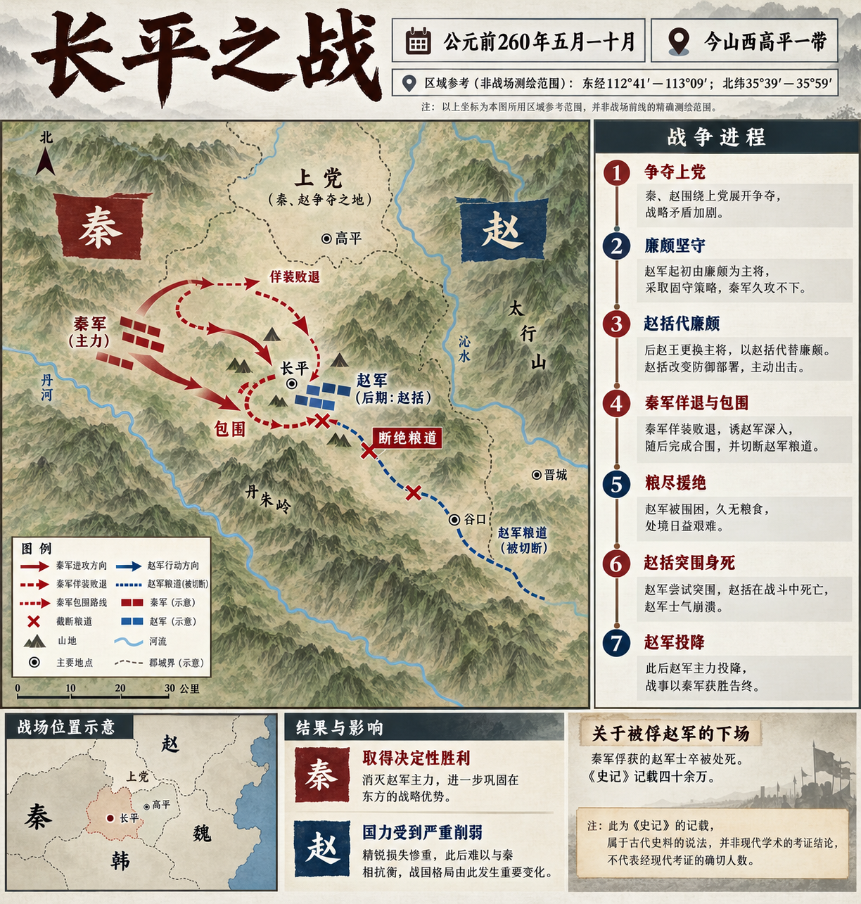
장평 전투 역사 인포그래픽
Battle of Changping Historical Infographic
‘장평 전투 역사 인포그래픽’은(는) gpt-image-2.5로 만든 작품입니다. OpenZhenZhen에서 원본 프롬프트와 생성 예시를 살펴보고 새로운 창작에 활용해 보세요.
프롬프트
중국어 프롬프트
设计一张严谨、详实的中文历史信息图,主题为长平之战。顶部准确标注标题“长平之战”,并设置时空栏:“公元前260年五月—十月”“今山西高平一带”。把来源给出的经纬范围明确标成区域参考,不要误作实测战线:“东经112°41′—113°09′;北纬35°39′—35°59′”。页面以地图和精简时间线组织内容:秦赵争夺上党;赵方统帅由廉颇改为赵括;秦军以佯退、包围和断粮道形成围困;赵军粮尽,赵括突围战死,余部投降。结果栏说明秦军决定性获胜、赵国实力遭受重创。如需呈现被俘士卒死亡人数,只能写作“《史记》记载四十余万”,并清楚注明这是古代史籍的记载,不是现代核实统计。仅用箭头、地形符号、粮道图和抽象兵力标记表达战局,不画人物肖像,也不表现血腥暴力。中文标签简洁清楚、间距充足;不虚构日期、除上述有明确来源限定的史籍记载外不添加精确兵力数字,也不加入无依据结论。使用克制的历史地图配色和清晰的信息层级。不添加无关文字、标志或水印。
영어 프롬프트
Design a detailed, fact-conscious Chinese historical infographic about the Battle of Changping. At the top, use the exact title “长平之战” and an orientation strip reading “公元前260年五月—十月” and “今山西高平一带”. Show the source-provided coordinate bounds as a clearly labeled regional reference, not as a surveyed battlefront: “东经112°41′—113°09′;北纬35°39′—35°59′”. Organize the page as a map plus concise timeline: Qin and Zhao contend over Shangdang; Zhao's command changes from Lian Po to Zhao Kuo; Qin uses a feigned retreat, encirclement and supply-line cutoff; the trapped Zhao army runs out of provisions, Zhao Kuo dies during a breakout, and the remaining force surrenders. In the outcome panel, state Qin's decisive victory and Zhao's severe weakening. If noting the captured-soldier death toll, phrase it only as “《史记》记载四十余万” and visibly qualify it as the ancient source's report, not a modern verified count. Use arrows, terrain symbols, supply-route diagrams and abstract troop markers only—no human portraits or graphic violence. Keep Chinese labels crisp, concise and well separated; do not invent dates, exact troop totals beyond that qualified record, or unsupported claims. Use restrained historical-map colors and a clear information hierarchy. No unrelated text, logos or watermark.
더 많은 이미지·동영상 프롬프트 보기 · 이미지 생성 · 동영상 생성 · AI 캔버스에서 만들기